
Audubon Park Historic District

AP
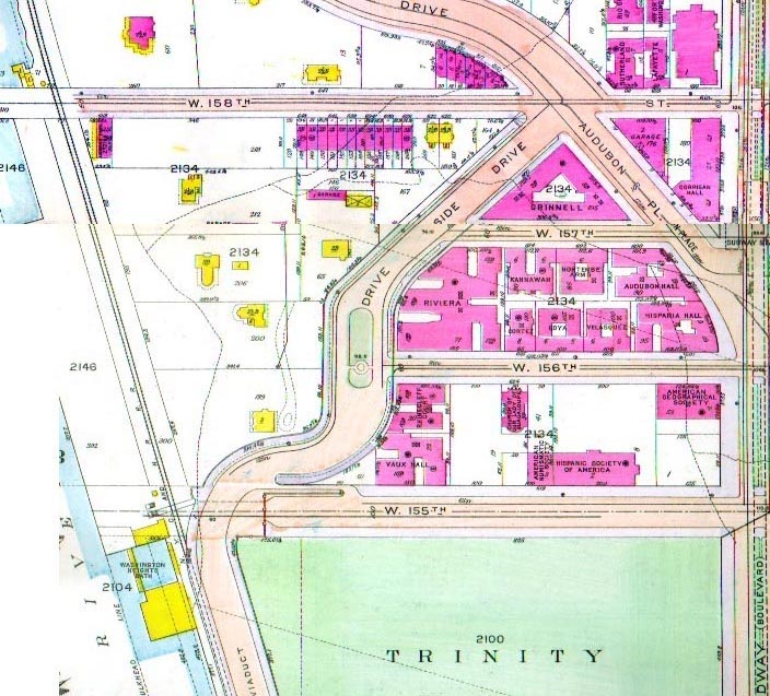
Bromley Map 1916: Audubon Park detail
By 1916, newly constructed apartment buildings covered all of the Grinnell property in Audubon Park east of Riverside between 156th and 158th Streets. One block south, the Hispanic Society of America and American Geographical Society shared Audubon Terrace with Nuestra Señora de la Esperanza. On the river side of the drive, Audubon's house – by this time commonly known as Minnies Land, which had been the name of the entire estate when Audubon was alive –sat against the stone retaining wall of Riverside Drive. (North of West 158th Street was the grand Wheelock Mansion.)
In 1916, present-day Edward Morgan Place still bore the name Audubon Place; its path is the same today, breaking off from Broadway (at bottom right, with its older name "Boulevard" in parenthesis), and connecting to Riverside Drive at 158th Street. The row houses on 158th Street still exist, though the two closest to the river are in dire need of repair. Reginald Pelham Bolton, author of Washington Heights Manhattan: Its Eventful Past and a community activist who fought diligently to save the Audubon House and to have the land between Riverside and the Hudson converted to a park, lived at 638 West 158th Street (the sixth row house from the west – left on the map).
(The slight distortion in Riverside Drive north of 158th Street on this map is because it is a composite of two pages in Bromley Insurance Maps of 1916.)
Webmaster's collection
Webmaster's collection