Audubon Park Historic District

AP
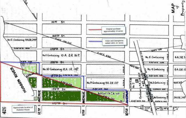
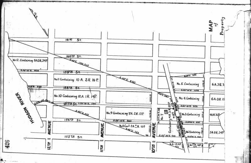
Minnie's Land : City Registry (Libor 444, Page 426, 1843)
Webmaster's collection
Top map shaded to show the original Minnie's Land footprint (dark green)
and the addition parcels Victor Audubon added to Minnie's Land (light green) in 1843. Bottom map is the unshaded original.
This map accompanied Matthew Morgan's 1843 land purchase from Samuel Watkins, who inherited this portion of the Watkins-Maunsell farm from his aunt Elizabeth Maunsell. Morgan paid $16,731.82 for the land and a house that John Watkins (Samuel's father) had built around 1767. (The house is still visible in the 1851 Dripps map, but does not appear here. It sat on the south-east corner of 10th Avenue and 156th Street.)
1691
The slanting lines represent the boundaries established when Harlem's settlers drew lots for the land on Jochem Pieter's Hills, as they called lower Washington Heights. Allotment number fourteen, which included the future Audubon Park, fell to Jan Dyckeman and Jan Nagel along with allotments eleven through thirteen, all four allotments eventually coming into Dyckeman hands when he married Nagel’s widow. Jan Dyckeman died in 1715, leaving the property to his son Gerrit, who passed it to his son Jan (who anglicized his name to John Dykeman). He sold this portion of his property to John Watkins 1767.
1767
John Maunsell and John Watkins bought adjacent pieces of the Dyckman property, including the future Minnie's Land and Audubon Park. Watkins and Maunsell were related through their wives, Lydia Watkins and Elizabeth Maunsell, two of the six daughters of Richard and Mercy Stillwell. Before the American Revolution, Watkins mortgaged his land to Maunsell, so that he could add to his property, but left the debt unpaid when he died in 1786. Maunsell foreclosed, but delayed action until the early 1790s, when Samuel Watkins (John and Lydia's son) bought the land at auction and then promptly sold it to his uncle for the same amount. Maunell allowed Lydia and her younger children to remain on the property. At his death, his wife Elizabeth built a large house on the Kingsbridge Road near 157th Street, just north of her sister's (visible on this map to the left of "No. 7). Lydia died in 1811 and Elizabeth, died (childless) in 1816, leaving all of her property to Lydia's surviving children, Samuel, Elizabeth Dunkin, and Lydia Beekman, who divided the property into three sections. Elizabeth Dunkin's share (the middle section) included the future Minnie's Land and Audubon Park.
1835
In 1835, Elizabeth Dunkin sold most of her property to James and Eliza Conner, who then formed a speculative partnership with Richard and Mary Carman, who had already bought part of the southern portion of the Maunsell property. They expected New York CIty's Board of Aldermen to purchase eighty-six acres of their land for a "rural cemetery." When that didn't happen, they lost the land in foreclosure proceedings to the New York Bowery Life Insurance Company.
1841
On October 1, 1841, The New York Bowery Life Insurance Company sold fourteen acres of the Watkins-Maunsell farm to "Lucy Audabon (sic) wife of John James Audabon" (the dark green triangle on the top map) and twenty-nine acres to Richard F. Carman, who was repurchasing land he had lost a few years earlier. Eighteen months later, Carman sold his acres to the Trinity Corporation, which established a rural cemetery exactly where the Board of Alderman had considered laying one out a few years earlier. In July 1843, Victor Aububon purchased three parcels (light green on the map above) that "squared off" the triangular Minnie's Land that his father had bought for his mother eighteen months earlier.
1851
Lucy Audubon sold the eastern rectangle of Minnie's Land (between 10th and 11th Avenues) to Dennis Harris, who was accumulating property east and north of Minnie's Land. Over the next seventeen years, the Audubon family would sell all of their remaining property. Eventually, George Blake Grinnell, who moved to Audubon Park in 1857, would purchase approximately two-thirds of the land between 155th and 158th Streets west of 11th Avenue (Broadway).
Map Index:
City Register 1844
 | ||||
| ||||