Audubon Park Historic District


AP
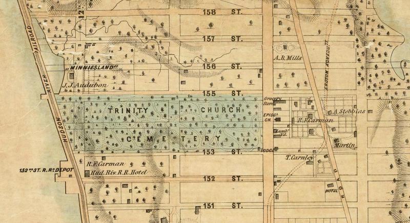
The "Dripps Map" of Manhattan north of 50th Street appeared the year Audubon died, when the Hudson River Railroad had been operating less than four years and few gridded streets existed in this part of the island. Tenth Avenue and 158th Street were both open, but barely graded and unpaved. Eleventh Avenue (Broadway) had not yet cut through Trinity Cemetery and the city would not open 156th and 157th Streets west of Broadway until after the turn of the Twentieth Century.
Minnie's Land has no drawn boundaries on this map and appears to encompass all the acreage from 155th Street to 158th, but it was no larger than in 1843 when Victor added his triangular purchases (see City Register 1844 map). By the time the Dripps map was published, Lucy Audubon had sold the eastern portion of the farm to Dennis Harris, including the house at 156th Street and Tenth Avenue that John Watkins had built in 1767. Just north of there was the house Elizabeth Maunsell had built after 1800, owned in 1851 by A. B. Mills, the leading merchant in Carmansville. The village itself had grown to include the Church of the Intercession, grocery store, lumber yard, and near the river, a hotel.
The pond that the Hudson River Railroad formed on the western side of Minnie's Land would silt over, perhaps with the addition of landfill, within a few years (see Dripps Map 1867).
Detail from Dripps Map 1851
Image copyright © 2000 by Cartography Associates. Images used under the terms of a
Creative Commons License.
Visit the
The David Rumsey Collection was started nearly 20 years ago, and focuses primarily on cartography of the Americas from the 18th and 19th centuries, but also has maps of the World, Asia, Africa, Europe, and Oceania. The collection includes atlases, globes, school geographies, books, maritime charts, and a variety of separate maps, including pocket, wall, children's and manuscript.
Map Index:
Dripps 1851