Audubon Park Historic District

AP
Images Courtesy of:
The Lionel Pincus and Princess Firyal Map Division, The New York Public Library, Astor, Lenox and Tilden Foundations
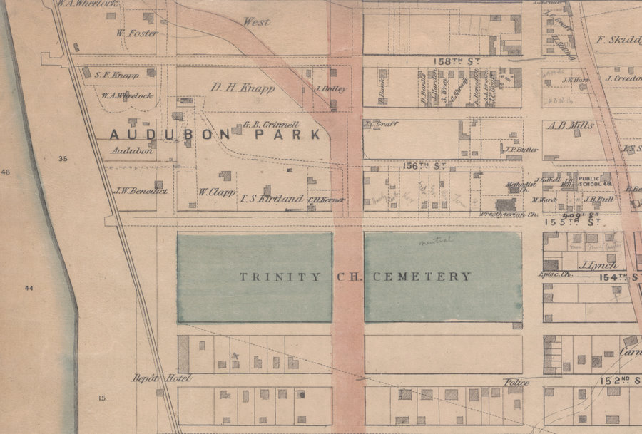
This detail from the Dripps 1867 map of Northern Manhattan shows the sharp contrast in development on the eastern and western sides of Eleventh Avenue (Broadway). In Audubon Park houses fit into the topography and face is various directions along a curvilinear drive, while houses on the eastern side of Eleventh Avenue sit on regularly lotted and gridded streets.
Carmansville has grown to include a police station and three churches. The Audubons were among the original founders of the Church of the Intercession (Episcopal) at 154th Street and Tenth Avenue (Amsterdam). In 1873, the Grinnells were instrumental in selecting the second location for the church, at Broadway and 158th Street. W. A. (William) Wheelock was an active member of the Washington Heights Presbyterian Church at the corner of 155th Streeet and Tenth Avenue and in 1868, donated an organ to the church, as well as funds to expand the rear of the pulpit to contain it.
At the lower left is the Depot Hotel, adjacent to the 152nd Street stop on the Hudson River Railroad. The stop's proximity to Audubon Park and the relatively short ride to lower Manhattan encouraged businessmen like Clapp, Benedict, and Grinnell to move their families from the center of the city.
The wide red-brown stripe is Eleventh Avenue (latter "the Boulevard" and now Broadway). A block north of the cemetery, the original avenue turned northeast across Audubon Park and would eventually become Boulevard Lafayette when the Boulevard followed the path of Eleventh Avenue northward.
Detail from Dripps Map 1867
Map Index:
Dripps 1867